News
Mikkeli develops 3D modeling tool for tracking on-site CDW flows
14 Sep 2021
As part of its work in CityLoops, Mikkeli has been developing a 3D model for drone imaging to be used on demolition sites in the city. This tool will allow the documentation and modeling of material flows during the demonstration actions in Mikkeli, and will help track and estimate the quantities of the various materials on site. The obtained data will then be added to a digital databank.
Mikkeli’s 3D model is a combination/adaptation of two drone-based applications that are already being used for respectively measurements in the mining sector and construction site monitoring in the AEC sector. The city has found that this tool is easy to use and cost-efficient.
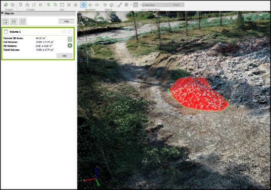
The tool works as follows: First hunderds of photo’s are systematically by a drone flying over its targetted site. The image cluster is then turned into accurate 3D and 2D data by using image-based modelling software, enabling the measurement of relevant material characteristics (e.g. volume, weight, density, etc). If the drone is equipped with special sensors, it may be able to idenitfy different materials and their quality.
Using this tool, Mikkeli has managed to do drone monitoring and data collection 1-2 times per week, gaining many relevant reuslts about the materials available on its demonstration sites. One minor setback is that tracking material flows turned out to be more difficult than originally planned, because demolished waste is transferred directly into demountable containers.
All news